Melting mountains and returning floods — Swat’s climate emergency
⚡ Quick Summary
SWAT: On June 27, authorities issued a Glacial Lake Outburst Flood (Glof) alert for the northern districts of Khyber Pakhtunkhwa, including Swat, warning that soaring temperatures were expected to accelerate snow and glacier melt across mountain valleys and increase the risk of flash flooding, landslides and sudden inundation downstream.
SWAT: On June 27, authorities issued a Glacial Lake Outburst Flood (Glof) alert for the northern districts of Khyber Pakhtunkhwa, including Swat, warning that soaring temperatures were expected to accelerate snow and glacier melt across mountain valleys and increase the risk of flash flooding, landslides and sudden inundation downstream.
Authorities urged monitoring of vulnerable sites, evacuation preparedness and public awareness in communities living along rivers and streams.
For the residents of Swat, however, the warning did not sound theoretical.
It reopened memories of a crisis that has unfolded over more than a decade, one measured not only in damaged roads and collapsed bridges, but also in disrupted identities, broken landscapes and communities learning to live with uncertainty.
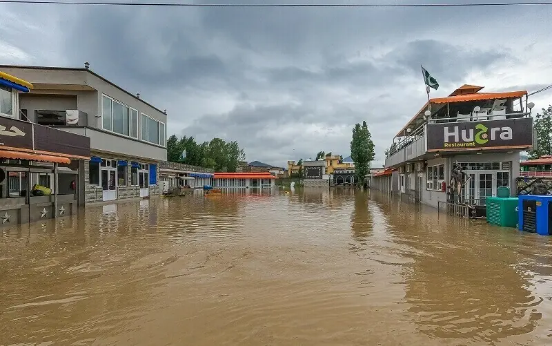
The Swat River has always been dynamic. Its channels shift, widen and reclaim floodplains during periods of high discharge. Yet in recent years, changing climate patterns combined with expanding development have altered the relationship between people and the river.
Satellite-based information published through Space4Climate, powered by the Pakistan Space and Upper Atmosphere Research Commission (Suparco), has highlighted how urban expansion into active floodplains at Bahrain increased exposure to flood damage.
Comparative imagery published for 2010–2022 shows substantial construction along sections of the river corridor, narrowing natural water pathways before the destructive floods of August 2022.
According to the Emergency Events Database (EM-DAT), the country has faced 89 flood events in the last 25 years, with impacts becoming more severe due to increasing urban expansion and development within active riverbeds and floodplains.
Using satellite-based monitoring, Suparco provides continuous assessments of river behaviour and surrounding land use, supporting informed decision-making for flood risk reduction and climate-resilient development.
Normal river water as of May 2022 appears light blue in this satellite image of River Swat and its tributary. — via Space4Climate
River water during the August 2022 floods appears muddy in the channels in this satellite image of River Swat and its tributary. The image highlights the risks to the settlements (outlined in yellow). — via Space4Climate
The implication extends beyond one town: climate hazards become more destructive when natural river systems lose space to absorb extreme flows.
Long before flood damage became international news, communities in Upper Swat had already begun documenting change. From Gabral to Mankiyal, from Matiltan to Daral, repeated floods and climate-linked extremes since around 2010 have reshaped everyday life.
Yet physical destruction tells only part of the story.
Teachers, local organisers and cultural workers increasingly speak about less visible impacts: anxiety during monsoon seasons, prolonged uncertainty among displaced families, changing settlement patterns, and the gradual weakening of community traditions rooted in place.
For many younger residents, repeated disaster cycles have altered how they imagine their future in the valley.
Among those who have consistently spoken about these wider consequences is Zubair Torwali, a cultural and linguistic activist and researcher from Upper Swat.
Torwali has repeatedly argued in public discussions and writings that development and climate responses in mountain regions should not be reduced to engineering solutions alone.
“Mountains are not empty landscapes,” he has said in various public forums and interviews over the years, emphasising that when communities are displaced or landscapes transformed, languages, memories and cultural practices are also placed at risk.
Local activists and researchers have similarly argued that repeated environmental shocks in Upper Swat affect social cohesion, oral traditions, seasonal movement patterns and people’s sense of belonging. For many families, recovery is no longer a single rebuilding effort; it has become a recurring condition.
The August 2022 floods marked a moment of national reckoning. Across northern Pakistan, extreme rainfall combined with swollen rivers to overwhelm settlements and infrastructure.
In Bahrain and the surrounding areas of Swat, the destruction has reignited debate over land use, river governance and construction practices inside active flood corridors.
Satellite assessments later drew attention to the overlap between damaged structures and historically active river areas.
Climate scientists increasingly warn that warmer conditions amplify hydrological extremes: accelerated glacier melt, more intense rainfall and unstable mountain systems.
The current Glof warning again places Swat at a crossroads. Authorities have advised communities to avoid riverbanks, maintain evacuation readiness and strengthen local monitoring systems. But adaptation may ultimately require broader choices.
Scientists argue for stricter floodplain regulation, better mountain planning, protection of natural river corridors and investment in community-based resilience.
Local voices add another requirement: climate adaptation must also protect people’s relationship with place.
In Swat, the question is no longer whether the mountains are changing. The question is whether policy, planning and public memory can change quickly enough to live with what comes next.
📰 Related Articles
Atiku sympathises with Lagos flood victims
Punch NigeriaWabara rallies diasporans to protect Nigeria’s democracy ahead of 2027
Punch NigeriaAgbakoba backs state police, warns against political control by govs
Punch NigeriaButchers hail Kaduna gov’s abattoir upgrade, say cold rooms end meat waste
Punch Nigeria2026 sustainability rating excites ABUAD as Afe Babalola sets new target
Punch Nigeria