The week begins with the arrival of a cold front and intense rain across the country; see the situation in your region
⚡ Quick Summary
After days marked mainly by dry air, a cold front begins to bring more significant rain from this Tuesday (9).
After days marked mainly by dry air, a cold front begins to bring more significant rain from this Tuesday (9).
The system moves through the south of Brazil on Monday night and advances towards the coastal region of São Paulo until Wednesday. Along the way, there is a risk of storms and strong winds.
According to meteorologists, the rains will begin to intensify at the end of this Monday (8), with accumulations that could reach 100 millimeters.
From Tuesday (9), the cold front establishes itself and the forecast is for intense rain in much of the South, North and Southeast. (See map below)
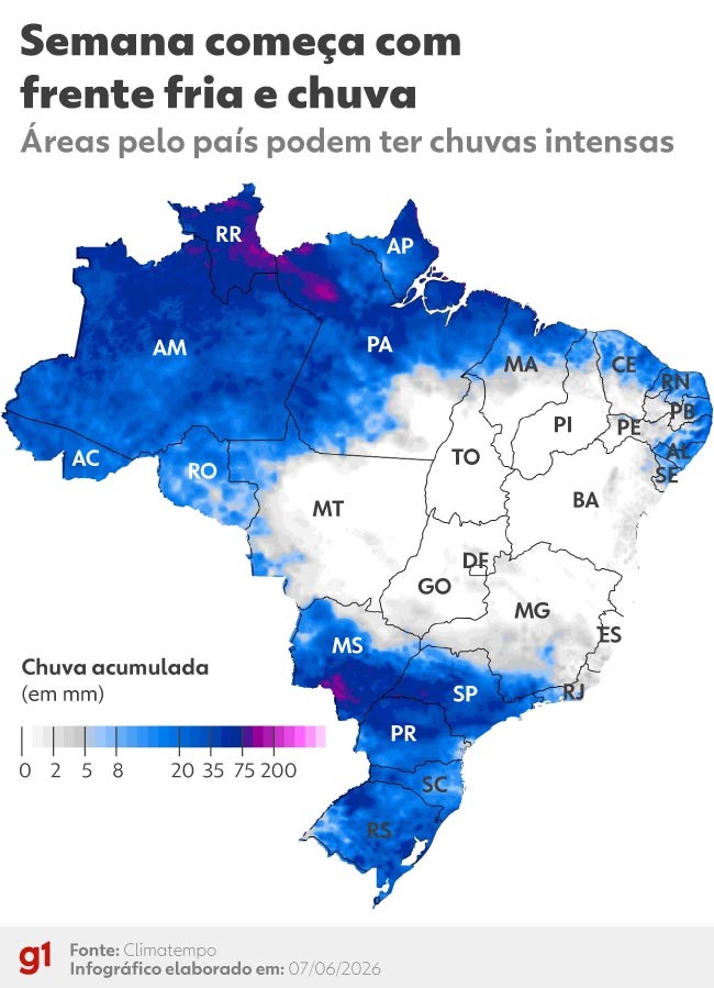
Map shows states affected by rain this week
Art g1
The most significant accumulations, which can reach 150 millimeters, are expected for areas of Mato Grosso do Sul, Roraima and Pará.
In Roraima, nine of the state's 15 cities are already in an emergency situation due to the heavy rains of recent weeks.
Meanwhile, the cold won't let up. After the cold front passes, a new mass of cold air should establish itself, keeping temperatures low in the South, part of the Southeast and the Midwest.
📰 Related Articles

Uber of celebrity drugs
Observador
With a bad face and a reputation for aggressiveness, the symbol bird of RS is considered 'Sentinel of the Pampas'; title born of legend
G1 Globo
After viral imitation, Matogrosso jokes and warns Zé Neto: 'You're going to have to pay'
G1 Globo
From 'crown' to triple encore: Matogrosso and Mathias liven up Americana with good humor
G1 Globo
Legal abortion: more barriers for child rape victims - The Issue #1734
G1 Globo