
Unseasonal rain and winds of up to 100 km/h hit Brazil in a week of unstable weather
⚡ Quick Summary
Meteorologist talks about the return of rain and falling temperatures in Paraná The weather forecast for the next few days indicates an unusual scenario for this time of year in much of the country.
Meteorologist talks about the return of rain and falling temperatures in Paraná
The weather forecast for the next few days indicates an unusual scenario for this time of year in much of the country. Starting this Wednesday (10), a sequence of low pressure areas, cold fronts and extratropical cyclones should spread rain across the South, Southeast and Center-West, with accumulations that could exceed 100 millimeters in some locations.
In addition to the rain, the National Institute of Meteorology (Inmet) issued warnings for storms in areas of the South and Central West. Winds between 60 km/h and 100 km/h are forecast, heavy rain and the possibility of hail.
The episode must reach at least 11 states, in addition to the Federal District:
Rio Grande do Sul,
Santa Catarina,
Paraná,
Mato Grosso,
Mato Grosso do Sul,
Goias,
Sao Paulo,
Minas Gerais,
Rio de Janeiro,
Holy Spirit,
Rondônia.
According to the institute, instability is expected to persist throughout the second half of June and continue until the first days of winter, which officially begins on June 21st.
Inmet
Where the rain is expected to be heaviest
The largest volumes are expected between Mato Grosso do Sul, Paraná and the interior of São Paulo.
Meteorological models indicate accumulations above 50 millimeters in several areas and volumes that can approach or exceed 100 millimeters in isolated points.
In Mato Grosso do Sul, rain is expected to occur at various times over the next few days, accompanied by thunderstorms and the possibility of localized thunderstorms.
In Paraná and Santa Catarina, the forecast is also for frequent rain between Wednesday (10) and Friday (12), with a risk of gusts of wind and hail.
Inmet predicts accumulations that could reach 50 millimeters in just 24 hours in areas of western Paraná and Santa Catarina.
In São Paulo, the rain should gain strength mainly in the interior of the state. The highest volumes are expected in regions close to the border with Mato Grosso do Sul and Paraná, but instability tends to gradually advance to other areas throughout the week.
Minas Gerais also appears on meteorologists' radar. Although the rain is not expected to be as widespread as in São Paulo and Mato Grosso do Sul, there is a possibility of strong and localized showers, especially in the Triângulo Mineiro and the south of the state.
Rain in RS
André Ávila/ Agencia RBS
Rain reaches areas that would normally be dry
What makes the episode unusual is the moment in which it occurs.
June is part of the dry season in the Central-West and much of the Southeast. At this time of year, rain events tend to be rare and, when they do happen, they are usually quick and not very voluminous.
In cities such as Brasília, Goiânia and Cuiabá, most of the annual precipitation is concentrated between November and March. During winter, rain typically gives way to dry air and low levels of humidity.
Therefore, even moderate accumulations would already be considered atypical.
According to Climatempo, in less than two weeks some locations may record more rain than the historical average for the entire month of June.
In much of the Southeast and Midwest, the monthly average at this time of year varies between 20 and 80 millimeters. With the current forecast, this volume could be reached or exceeded even before winter arrives.
What is causing the change in time
sky of Presidente Prudente; sky of the interior of São Paulo
Beatriz Jarins/g1
Rain is the result of the successive action of different meteorological systems over South America.
The first cold front of the sequence began to form this week in southern Brazil. On Wednesday (10), a new area of low pressure should gain strength between Paraguay, the South and the Central-West, favoring the formation of extensive areas of instability.
On Thursday (11), this system should give rise to a new cold front associated with an extratropical cyclone in the ocean. Although cyclones remain away from the Brazilian coast, they help organize atmospheric circulation and transport moisture to the interior of the continent, creating favorable conditions for the formation of heavy clouds.
The forecast also indicates a new round of instability between June 17th and 19th, when another similar system is expected to form between Paraguay and southern Brazil.
Warning for strong winds and hail
Igor Jácome/G1
In addition to high volumes of rain, meteorologists are monitoring the risk of isolated storms.
Inmet has issued an orange alert for areas in the south of the country, with a forecast of rain between 30 and 60 millimeters per hour or up to 100 millimeters throughout the day, in addition to gusts that can vary between 60 km/h and 100 km/h.
There is also a possibility of hail.
The combination of heavy rain, wind and already damp soil can cause occasional problems, such as flooding, falling trees and interruptions in the power supply in some locations.
🗞️ 2 sources covered this story

📰 Related Articles

Moro comfortably leads the race for the government of Paraná, according to new research
CartaCapital
VIDEO: Motorcyclist is injured after crashing into a car in the interior of SP
G1 Globo
Farmer son of Brazilians who was missing for 103 days is now escorted by police officers; criminal group is investigated
G1 Globo
Woman is arrested for failing to comply with precautionary measures in favor of her ex-partner in Santarém
G1 Globo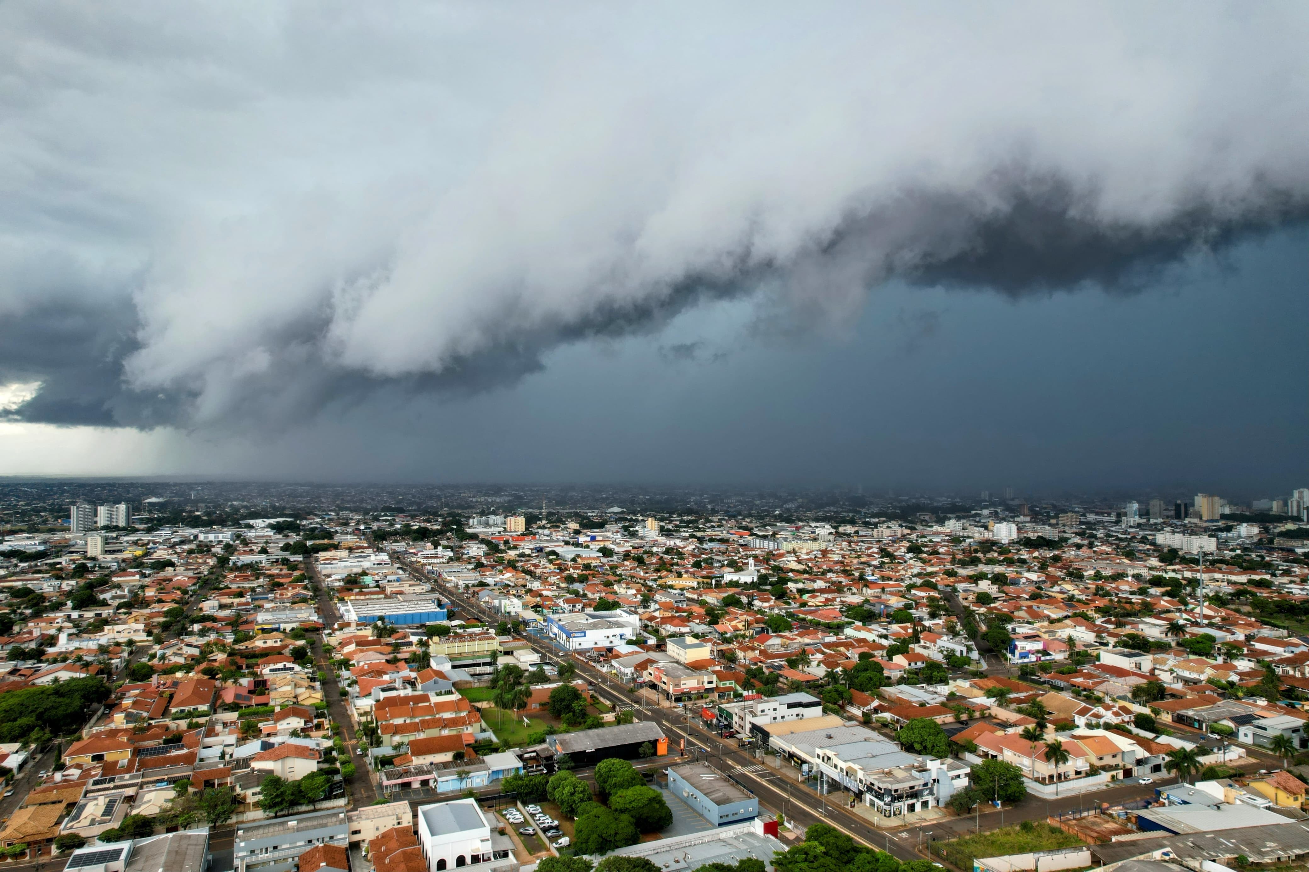
Civil Defense warns of risk of heavy rain and intense winds in Campo Grande
G1 Globo